Achtung: Der Weg durch das Schaftobel ist aus Sicherheitsgründen gesperrt – der Grund sind die fehlenden/maroden Brücken (T4).
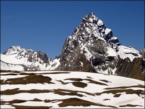
Ganz oben kommt man sehr nahe an das Tinzenhorn heran. Auf der letzen Ebene vor dem Corn da Tinizong wartet ein glasklarer See und viel Blockstein.


Gesamtstrecke: 24352 m
Maximale Höhe: 2572 m
Gesamtanstieg: 2228 m
Gesamtabstieg: -2100 m
Gesamtzeit: 07:59:38
Download file: 2017-07-05 Aint Igls Lajets Alvaneu.gpx 615-544-7786
Maximale Höhe: 2572 m
Gesamtanstieg: 2228 m
Gesamtabstieg: -2100 m
Gesamtzeit: 07:59:38